

Information Station with River Levels notice seen in mid February 2020
Hydro have a useful
website www.hydro.com.au/water/lake-levels
East Wilmot Track: Lucy's Track to East Ellis Picnic Area: about 2 hours.


Barbeque Pool Shelter


East Ellis Crossing
Dooley Track


It is sad to know (via a bushwalk forum) that Bill Shepherd (billshep2) passed away on the Badgers Ridgeline Tk (on top of the Morgan Skyline) on Friday 20th November 2020.
Bill died doing what he loved, bushwalking and track maintenance on the tracks and trails all over northern Tasmania. Bill spent an enormous amount of time upgrading and maintaining the extensive network of trails along the Wilmot River and updating his blog for all to use...https://wilmotwalkingtracks.com/ His last entry was on the 13th Nov 2020. Billls legacy will live on for ever for all of us who have had the pleasure to follow in his footsteps. His legacy..
Reminds me of Wilmot River pack carry walk in 2016.


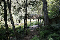
A nice shelter after a short steep zig zag down from the start and also
the resting place before the climb on the return.


Where I met Bill and followed him on a short cut when he enjoyed a swim.


I was told of Payne Camp Shelter and
walked out the next day via Shoestring Crossing on Dooley Track
Castra Circuit, northeast side of Nietta in Northern Tasmania


Old memo-map Topo 25k. Parking was just off the road.
Started near Nietta Creek and walked in a clock-wise direction. The track was marked.


From the start, it took about 10 minutes to the first tier. Castra Falls has two tiers.
- Secret Place Cascades.


It was just a short side trip to The Place and it was well worth searching.
- Silver Falls: Steep descent with loose rocks - use safety rope.


Bills Safety Rope for hikers to grip onto to help getting down and
pulling themselves back to the track.


Silver Falls also has two tiers.
- Step Falls


Continued on along the circuit to Step Falls.
Backtracked to the junction and took the track heading east to Gaunts Road, about 150m south of the start, then walked along the road back.
Castra Circuit
Minnow Falls, east side of Mt Roland
- The new route


.. with beautiful wooden signs on the track to Bottom Falls and the return track.
- The old route (Minnow Falls Skyline) a hard and long day. Be prepared and well-equipped and start early.


Across the ridge and the escarpment.
Mapping: The Tasmanian land info website www.thelist.tas.gov.au is very useful for checking out the routes. The main tracks and forestry roads are on there. Its more current than the printed maps.