
We travelled through SA and Alice Spring because we had been there before.
Here is the first photo:

Good bye to my wear+tear boots at the SA/NT border rest area. There was an overflow car park on the other side of the highway. This was our 4th night. The first was at Bordertown Serviceton camp (near road), the second at Crystal Brook Park (near railway line) and the third at Bon Bon. Went past Lake Hart which was nice but there was no toilet.
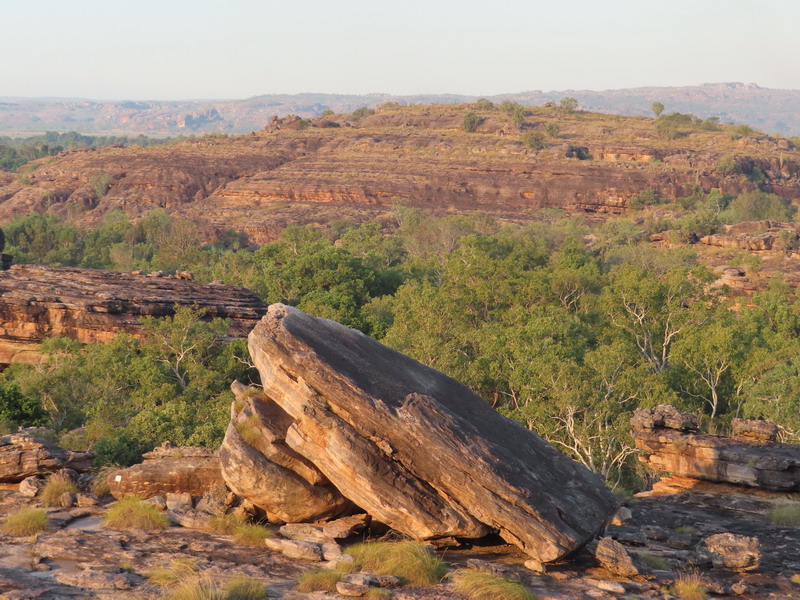
First location, the Devils Marbles (Karlu Karlu) near Tennant Creek, the heart of Australia's outback with short walks and wonderful views of the granite boulders in the late afternoon or at sunrise. Campground for all types of camping with DIY fees. But, please behave yourself: leave nothing but footprints and take nothing but photos and don't overstay.


My first day walk: On the next day, Allan's camping van was left at the campground and after sunrise photos of the mables, we drove to Davenport Range for Whistleduck Creek walk around a large desert waterhole. Then returned to the marbles for sunset photos. It was rather cool at night.


Left Devils Marbles after more sunrise photos and continued north heading for Tenant Creek. Went to the mining museum and information centre and then drove on to a wayside stop just before Daly Waters. It was getting warmer here about 28 degree in the day and 20 degree at night. All the blankets were put in storage.
Driving to beyond Katherine: had a rest stop and a check on mail at Daly Water. Swam at hot springs (open daily, free entry) and had lunch in Mataranka. Got information and supplies at Katherine and then to Pine Creek and the Pussycat campsite for the night.
Drove to Douglas hot springs and then did a short walk to Robin Falls.


Tennant Creek Telegraph Station


Robin Falls picnic area, about 15 km south of the little township of Adelaide River. BYO dunny if planning to spend an overnight here. We did not and continued on after a refresh in the creek.
Litchfield NP is one of the Top End's popular recreation areas. It has deep pools and permanent creeks. It is best reached from the Stuart Hwy via the little township of Batchelor with temp of 35 degree. There is a general store and a park ranger information office. Don't forget to fill up petrol before heading in. Popular activities include: swimming, bushwalking, bird watching, camping and 4WD.


Florence Falls. It's a short walk from the car park to the Falls viewing platform. The area has a campground with showers and toilet facilities. DIY camping permit. The pool below, great for swimming and is accessed via about 150 steps.
Spent the day walking and swimming at the waterholes in the Florence Falls area in Lichfield Park. It was 33 degC in the days and 20degC at nights. It was rather warm and almost no chance of rain. Need to see all the falls in the area before they dry up.
Spent the day walking and swimming at the waterholes in the Florence Falls area in Lichfield Park. It was 33 degC in the days and 20degC at nights. It was rather warm and almost no chance of rain. Need to see all the falls in the area before they dry up.


Buley Rockhole. A series of small waterfalls + rockholes, the perfect place to stay cool and relax. A group of school girls were having fun in the rockhole. Please note: this campground was not caravan friendly access.
The Lost City: 4WD track - 21 km return
The start of the drive is about 10 km from Termite Mounds and 4 km from the turn off to Florence Falls and Buley Rockhole campgrounds. It is a natural formation of free standing pillars. Open from May to November - seasons permitting


Wangi pics taken before noon. Those aquatic noodles were put in good use.


DIY camping permit. Toilet and solar hot water shower available.


Wangi Falls in the late afternoon light.


Exploring the local Falls and waterholes. Went to Walker Creek in the afternoon to visit the swimming holes there where I discovered that we were not alone. A walker was having a rest and a swim. The warm rockpools were so inviting that I did not hesitate to get in and have a quick dip. I was regretful to leave and thought of a revisit to see the rest of Walker Creek.
Walker Creek. There are a few options:
- Start from the picnic car park and take a short walk along the creekbank to a great swimming spot.
- It's possible to do an overnight trip and walkers can use the signboard to book one of several campsites. This is a very popular walk with great swimming + camping spots. Book in early and start the walk early. Can be hot in the afternoon.
- For keen bushwalkers, there is a long-distance Tabletop Track, that is a 39 km loop with links en route to Florence Falls, Buley Rockhole, Wangi Falls and Cascades.


Rocky Falls


Rose early for the revisit to walk a long Walker Creek. Took 5hrs to walk 5kms
as I turned into a Water Baby and needed to dip in 4 waterholes along the way.
Had an early swim at Wangi Falls, then took a drive back to Bachelor as we ran out of LPG.
Went to Termite Mound on the way back and then after lunch we went to Tolmie Falls. The Falls walk ends at a lookout with stunning views. Be there in mid-afternoon for the best light


(L) Termite Mound (R) Tolmer Falls Lookout
Our plan to Tjaynera Falls was cancelled due to being blocked by a flooded Sandy Creek. Allan did not want to drive through over half of metre depth of croc infested water over 100 m wide.
Darwin and region
After leaving Wangi campsite, we moved on to the Darwin River Tavern which provided free parking with a pub meal purchased. Excellent Barra meal.


Pub campground with views of sunrise+set

Went to the Berry Springs hot pool and spent the morning in hot water. Then drove on to Coolalinger (just northwest of Humpty Doo) and set up camp. Did laundry (while Allan visited a doctor for sore throat) and grocery shopping
Drove to Darwin City hunting for bathers. The current one had not been used for a while and it seemed a bit small. Had roast duck lunch, then drove along western coast visiting Cullen Bay, Eastpoint Reserve, and Nightcliff for the sunset.
Left Coolalinger for Mary River NP on the Arnhem Hwy. The turn off is just opposite to the Old Jim Jim Road - 4WD only. Went to Mary River Billabong along the way and arrived at Couzens Lookout campsite at about 2pm. Set up camp and then started taking bird pictures.


Couzens Lookout and Camping Area provides nice views early and late in the day.
Fees apply (collection box). A perfect place for camping and bird watching.
Fees apply (collection box). A perfect place for camping and bird watching.


After breakfast, set off for the Rockhole boatramp, and then to Shady Camp, about 50km north of our Couzens Lookout campsite. Lots of water lillies Billabongs and birds. Shady Camp has a wild croc and bird viewing hide


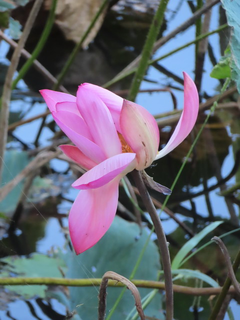
Lotus lilies


Shady Camp Billabong


A bit of patience paid off. A very large saltwater crocodile surfaced just after a small tourist boat went past. Wondered if it was the croc's occational feeding time. My first one on the NT and NthQld trip.


Egret and pelican. A Full List of Australian Birds


Eagle (Left) Corella (Centre)
Into Kakadu NP today. First stop was at park office to obtain a 7 day entry permits for two with fees of $30 each. Then, went to Mumakala Wetlands (off the Arnhem Hwy, south of South Aligation River, not far from Kakadu Hwy turn off) and observed the local birdlife.
Then off to Jabiru Visitor Information Centre to check park plans and drove up the East Alligator River to the Merl CG.


Ubirr
Exploring the rest of the East Alligator River area. Did the 1km Ubirr loop to see Aboriginal rock art sites. An additional climb of 250m took us to the top of a rocky outlook for stunning 360* views over the floodplain. Open 8.30am to sunset in dry season (April to November).


Merl Camping Area with good facilities. Fees apply (collected on site).
We also did the 2.5 km sandstone river walk


East Alligator River

Pic taken from the viewing platform near Cahills Crossing (with a high clearance 4WD), an access to Arnhem Land. Then drove back to Jabiru and onward 20km south to another mosquito infested campsite.
From the mosquito infested Malabanjdju campsite we walked to the Gubara Ponds for lunch and then the Nourlangie wetlands for more bird spotting.


We left the mozzies and headed to the croc infested Yellow Waters wetland (part of the South Alligator River floodplain) and the Yuppie infested Cooinda Resort. Then drove down the '4WD' road to park the van at Garnamarr CG and visit Jim Jim Falls and surrounds for 3 days


 Ibis (L) Magpie Goose (Centre) Masked Lapwing (R)


Moved to Gunlom (old South Alligator River Uranium Mine) and it was another boneshaker drive in. Went on a walk to a billabong (nothing to see here), to the waterfall top pool (and swim) and South Alligator lookout and then the waterfall plunge pool.


Went on a day walk to the Motor Car Creek Falls and pool and then to Boulder Creek. Nice plunge pool at Motor Car, but nothing at Boulder Creek.


The second wild croc!


 Ibis (L) Magpie Goose (Centre) Masked Lapwing (R)

Stone-Curlew spot on in the campground
A short walk to the Jim Jim Falls through monsoon forest and over boulders (2km return, allow 2hrs) and a very short swim around the Jim Jim plunge pool. It was icy cold compared to the normal NT rivers. No croc danger


Jim Jim Falls plunge pool
Today was the longer walk around the Jim Jim escarpment on the Barrk
Marlam track. Fairly windy this morning but the weather was still 100%
predictable. Cool night; hot dry day. 12km walk to the top and back
and a swim in the top pool took all day.


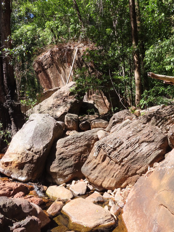
Moved to Maguk CG. There were several short walks to do at Maguk and the obligatory waterfall plunge pool at the end of the walk. Boneshaker access road.


Moved to Gunlom (old South Alligator River Uranium Mine) and it was another boneshaker drive in. Went on a walk to a billabong (nothing to see here), to the waterfall top pool (and swim) and South Alligator lookout and then the waterfall plunge pool.


Went on a day walk to the Motor Car Creek Falls and pool and then to Boulder Creek. Nice plunge pool at Motor Car, but nothing at Boulder Creek.


Wild flowers and views on an old exploration track


Motor car falls: 7.5km return. Allow 4hrs. Moderate marked track. Best time in wet season.

Overnight at Kambolgie Camping Area on the way back to Kakadu Hwy
Moving on to Katherine NP Planned to stay at Edith Falls tonight and stay for 3 nights with a day walk to the top pool and the Sweetwater Pool.


Today saw us do the 3km to the Edith Upper Pools loop and stop to swim in 3 different pools.


It would be great to camp overnight here. Lovely waterholes.


Departed to the other end of the Katherine Gorge NP to have a clean-up day in Katherine township. Visit the Tourist Info to plan Gorge activities.


Honey Eaters and Metallic Starlings (Right)
Moved to Katherine Gorge and did the local lookout walk before an evening swim.


Did the Southern Rockhole / Jedda Rock / Butterfly Gorge 19km day walk around the south walls of the Katherine Gorge.


 Did the two gorges boat cruise up Katherine Gorge as the three gorge was fully booked. Otherwise had a lazy day at KG.


Back to NT & Qld trip: Departed Katherine via the local hot springs pool and reached the Newcastle Waters wayside stop at dusk (just north of Elliott NT)
Drove most of the day to reach a spot near the NT/Qld border at dusk.


Stunning views of the First Gorge from Pat's Lookout.
The small waterfall at the Southern Rockhole was dry (R).


Allan at Butterfly Gorge and great views from Jedda's Rock (R)


The third croc.


Darter (L &R)


Below is photos of me taken in 1992, when I had joined Willis Walkabout
to do an extended walk in Kakadu and Katherine Gorge


When unsure if pack floating or not, a warm-hearted guy had given up his kayak for me.
Back to NT & Qld trip: Departed Katherine via the local hot springs pool and reached the Newcastle Waters wayside stop at dusk (just north of Elliott NT)
Drove most of the day to reach a spot near the NT/Qld border at dusk.