
For a long time I had not been to the Mt Feathertop area. If correct, my last trip up there would had been about one and a half decade ago. After having a look at the Bureau of Meteorlogy's website and knowing that there was a fine forecast for the next few days in the high country, and the possibility of the last chance for walking before winter, I was eager to pack and leave.
I had not walked for a while and was unfit; therefore, I chose a pack carrying walk to Mt Feathertop via The Razorback. The other two access tracks to the summit include the Bungalow Spur and North West Spur.
Closest Service Town: Bright (Visitor Info Centre, petrol stations, bakeries, shops and an outdoor store) is about 322 km from Melbourne. About 24 km after Bright is Harrietville, a small town with a handful of options ..
Recommended Map: Bogong Alpine Area 1:50 000


The Razorback
Start/End: Diamantina Hut parking area, Great Alpine Road, and about 1 km west of Mt Hotham Visitor Day Shelter (with flush loos). At the time of writing, half of the building is for walkers/hikers with tickets Falls to Hotham Alpine Crossing (trekking 37 kms, 3 days).
There is no car park at the start. On a fine day in Springs and Summer, parked cars can be seen on both sides of the Great Alpine Road. Visitors need to be well-prepared on windy, cold and freezing days. There is a log book at the start for just in case of emergency/search and rescue such as getting lost or fire.
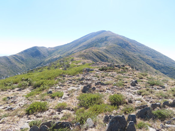
The open ridge above the treeline
Walk Info
Head off north on the ridge. The track is signposted at track junctions. Walk along the Razorback ridge with good views on a fine day.


the Federation Hut/Feathertop junction
About 0.5 km before Federation Hut (with two drop loos and a water tank), leave the main track and take the track to the summit.


View of the ridgeline of The Razorback sunset from the hut/campground with walkers/campers seemingly looking comfortable in their light weight hiking chairs. It was rather crowded and busy over the long weekend with good weather.
Walk Options
• A long day walk: 10.3 km in and 10.3 km return. Plus, 700 m walk up to Mt Feathertop summit and then walk 700 m back down. Another 500 m to the Federation Hut if in need of water refill and / or a loo break. An early start is suggested.
• An overnight pack carrying: pack with all your overnight gear including tent + sleeping bag + food (dinner + breakie + lunch + snacks) and water for the walk-in, etc.
To get to the summit in the day, it is suggested you make an early start. Walk to the hut, pitch the tent, get some rest, have an arvo tea, and then tackle the summit for the sunset (if lucky).
• Day One: Walk in 10 km to the hut / camping area and set up tent.
Day Two: Up to the summit and back down the camp.
Day Three: Walk out, return by the same route.
Note on the walk out: about 1 km south to Big Dipper (from 1714 m, ref Map), there was the low route option if you want to avoid the high route to the junction of The Razorback and Bon Accord Spur.
The summit track

Overflow campsite at the Hut/Feathertop junction called The Cross, 1730 m
It is a climb above the tree line. Take your time and take it all in.


It was worth the effort. Great spot for lunch with views.

Looking east towards Bogong High Plains and Falls Creek

Looking south towards Hotham and Dinner Plain.
The exposed ridge. Do not cross it in bad weather.


The domed MUMC Hut on NorthWest Spur photograph taken on my way back down to The Cross.
What can I say about this walk ?
- One of the best summit walks in Victoria's High Country
- Also, one of the most popular hikes in Australia. I will be back.
Notes: Avoid walking / hiking over a long weekend and during school holidays if you want to avoid crowds.