27 March 2021

Cape Hauy

 Located in Tasman NP, south of Tasmania. Access is via Arthur Highway (A9) to junction with Fortescue Bay road C344.  The 12km unsealed road is suitable for 2WD.  Camping fees apply for overnight camping at Fortescue Bay.  A park pass was required to undertake Cape Hauy Walk.

GPS Track log of day walk to Cape Hauy and back.

The Cape Hauy walk on 13 Feb 2019 was a warm-up for the three day, two night Cape Pillar walk. Started from Fortescue Bay campground. The track was well defined and maintained because it was part of Three Capes Track. It took about 4 hours return (9.4 km) graded Easy-Medium.

Outbound to Cape Hauy
     
Cape Hauy
    

Return from Cape Hauy

22 March 2021

Cape Pillar

Located in Tasman NP, south of Tasmania. Access is via Arthur Highway (A9) to junction with Fortescue Bay road C344.  The 12km unsealed road is suitable for 2WD.  Camping fees apply for overnight camping at Fortescue Bay.  A park pass was required to undertake Cape Pillar Track, part of Three Capes Track.
   
GPS Track log of Cape Pillar as a 3 day, 2 night walk (14-16 Feb 2019) on the well defined tracks.

Day 1: Fortescue Bay (Mill Creek campsite) to Wughalee Falls Campsite - 9.87km
The start of the Cape Pillar Track was on Fortescue Road located not far from the information board outside the park office. Leave the signposted track and road junction, follow the track south-west for 2km past Snake Hill and a further 150m past the old route heading to Mt Arthur.  

Continued the track south, then south-south-east for 2km to the signposted track junction on Tornado Ridge. Then turned left on to a steep descent track about 850m to Wughalee Campsite with tent platforms, a long drop loo and 2 small rainwater tanks.


One of the tent platforms at almost dry Wughalee Falls campsite (Fuel Stove Only) 

Day 2:  Walked to Cape Pillar and returned to Wughalle campsite - 15 km
Early hard work on the day was to walk 850m back up to the Cape Pillar Track. Continued on south towards Cape Pillar about 300m, we discovered an almost completed Bare Knoll campsite. We would camp here and save our energy and time on the steep descent and ascent.

    
A short and easy walk-in campsite unlike the down and up to/from the Wughalee Falls campsite

About half an hour later, we reached Lunchtime Creek.  I had been here twice some years ago and solo with a heavy pack.  Continued on about 150m or so, I could not believe what I saw, an official Munro hut with all the goodies including a cooking area with gas supplied and a viewing platform.  Of course, you get what you pay for on the Three Capes Track, unlike our budget way of hiking.
  
Cape Hauy in morning light from the viewing platform at Munro Hut 

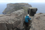
An outbound board walk leads 500m south into Corruption Gully, then swings south-east 1km onto Hurricane Heath. Follow the new track 400m east and 1km south to Perdition Plateau, then head south-south-west about 500m to the cliff edge. Continue along the cliff tops east to The Oasis, Triden Bluff, The Blade and Chasm Lookout.
       
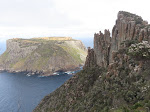
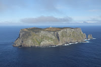
The Blade (250m) and Tasman Island

    
Chasm Lookout (277m) from The Blade (L). 
 
    
 Tasman Island and the narrow rocky ridge to the top of The Blade.

   
Coastline from Track and Lighthouse on Tasman Island (R)

  
Clear view of Tasman Island, In/Outbound board walk and 
Cape Hauy in late afternoon from the viewing platform at Munro Hut
Day 3: Retraced our steps on day 1.

19 March 2021

Anakie Gorge Circuit

Located in the south of Brisbane Ranges NP and about 84km West from Melbourne. 
Access options from Melbourne include: the Princes Freeway M1 (to Werribee) or the Western Freeway M8 (to Bacchus Marsh). Closest Town is Staughton Vale and about 1.3km to the Anakie Gorge Picnic Area with toilets, water tank, tables and tent sites.
GPS track log of the Anakie Gorge Circuit Track. 
Carry water. No sight of water seen on the track in mid March 2021

The track starts near the information board. Follow the track southwest towards the gorge past an old mine. Continued on for more than 600m to reach a track junction with an interpretive sign.

Leave Anakie Gorge Track and start climbing south to take on Ted Errey Nature Circuit (8km, 3hrs, Blue markers). Continue on climbing and following the rocky track for a few hundred metres to a knoll, then an easy 1km walk south then west beside the boundary fence to a track junction led to Nelson Lookout with a seat.
 
Nelsons Lookout (L) & The Outlook (R)

Back to the junction, follow the track south for about 400m and continue west about 2km on Nelson Track. At Switch Road and the Nelson Tk junction, turn left taking the track running beside the road for 500m.  Return to the road and walk another 150m to RedBeak Tk. Follow it west passing through a gate then continue to a Y-junction then turn right heading north about 750m to reach the junction of Outlook Track and the Burchell Trail (part of a three-day walk through the Brisbane Ranges). After the 100m side trip to the Outlook, back track to the junction then follow the Burchell Trail 1km NNW down then 1.5km north-east to Stony Creek Picnic Area with facilities such as: toilets + water tank + tables + tent sites.
Stony Creek Picnic Area 
Anakie Gorge Walk or the track linking between the Stony Creek Picnic Area and the Anakie Gorge Picnic is a pleasant 3km stroll, that takes about 1hr.

The drive home.
Dinner at Hanoi Mee: 140 Rouse St - Port Melbourne - Ph 9042 7921