
Nearest town is Deloraine (South) and it's about 5km from Great Lake North. Access from Lake Highway A5 of the Great Western Tiers in the alpine Central Plateau. There was no track to follow and it was a slow going because of difficult terrain. However, it was worth to tackle it

Did a 6 hour walk from Pine Lake to an overnight camp at Duncanson Falls on the central plateau, across 8 kms of peat bogs, scree slopes and scoparia thickets. It was very cold and a bit wet too by the end of the day.


A cairn was seen shortly after leaving the northern shore of Pine Lake and it was also the start of bush bash and rock hop. Adams Peak from the alpine central plateau. I had been up there before with a day pack. Wild flower out in late March.


A bit of time spent on looking for a shelter tent site. Very exposed up there.
Walked for 6 hours across scoparia infested peat bog back from Duncanson Falls on the Central Plateau. It was much better weather though.


Morning view from the camping spot. If weather permitting, we would love to stay another day here
to go further exploring. Warners Falls and Havelock Falls were not far away, just about 1km north of
us. It was also on the walk out if doing the circuit.
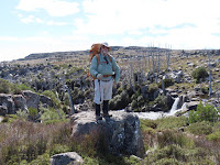
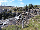

Photo op - pack on and off again. Duncansons Falls and Ritters Crag. Will be back.


Day 1 and 2 lunch stops. Back to Pine Lake car park.