
Closest town is Rosebery. Access via Murchison Highway (A10) and Anthony Road.
The start marked with a ribbon is near power pole D55 on Anthony Road, about 3km north of Lake Plimsoll and parking is off the road. The track is in the Murchison regional reserve.
To Lake Sandra (early Jan 2019)


The track led steeply up through rainforest then to alpine vegetation. Require navigation.


It was really windy when we were high up. The hard work was done and we could see our destination for the day from the hill. From here, the trail led north down to a small camp near the beach at northern Lake Sandra.


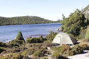
Mt Murchison 1278m from camp. As usual, a refresh comes before the cooking.


Many stops for photographing. Looking north from the track.


A little side trip with excellent views, also checked out the western access route up Mt Murchison. Sandra Murchison Traverse in the future came in mind


Looking west: Mt Read was about 5km away.


The route marked with cairns. About half way down, Anthony Road and Lake Plimsoll came into view.

Mt Murchison from the drive
The signpost for Mt Murchison Walk is about 4km east of the Lake Sandra walk start.
Graded difficult and should not walk in poor weather due to cliffs and drop-offs.