
Leaving West MacDonnell Range, we drove to Alice Springs to top up supplies and fill up fuel before heading to Kings Canyon, which is located southwest of Alice Springs. We stopped at Stuarts Well, had a cuppa and tried to find out the road conditions to see if we could take short cut to Kings Canyon via Ernest Giles Rd, and were told that the road was rough and suitable to high clearance 4WD only. Our option was to continue on Stuart Hwy and to take Lasseter Hwy, then Luritja Rd.
The Kings Canyon Rim Walk: 6km loop, 3-4 hours, medium.
The walk begins with a steep climb to the top of the range, which provides great mountain views.
There are track markers along the way and we came across few tourist groups.

Road side views and photo opportunity.


Uluru/Ayers Rock


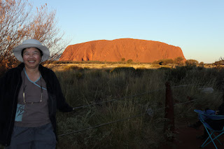


Car Sunset. Arrive early for viewing spot. Car with a roof top is the best viewing plate form. BYO snacks and drinks.


Uluru changed different colours at sunset and sunrise


Mt Olga Sunrise


Valley of The Winds


The climb (we did not).
Permanent closure will start from 26 Oct 2019 and the Aboriginal will jump for joy.
I had tackled it about 20 years ago just after the walking trip in Kakadu NP.
I am a veteran in public sector.
Permanent closure will start from 26 Oct 2019 and the Aboriginal will jump for joy.
I had tackled it about 20 years ago just after the walking trip in Kakadu NP.
I am a veteran in public sector.