Mt Howitt Return Walk
I travelled from Melbourne down the Princes Hwy and then to Licola, and then along the Tamboritha Road and Mt Howitt Road then pitched tent at Howitt Hut, off the Mt Howitt Road.
The next day, I continued on and travelled to View Point, and walked the 5 kms to Vallejo Gantner Hut where I met a walker who had been on AAWT for 10 days. I was told about the exposed tent site on Mt Howitt where I was planning to camp and so I decided to stay the evening with my walking companion. I was warned about the bush rats and so, for peace of mind during the night, I set up my free standing tent in the hut and the pack was also hung up. We had a long chat by the fire and talked about our hiking experiences. The similar interests brought us together and we exchanged our contacts and hiking tips.

A revisit to the Vallejo Gantner Hut after about two decades.
New: the outdoor table and the replacement of the old long-drop loo.
This was my first solo pack carrying hike for a few nights for a little while, so I was a little disorganised. In trying to catch up with a good weather forecast, I had forgotten to take my old track notes from the car. I was planning to walk to Mt Lovicks and the Bluff, but this was abandoned and so I walked back from Mt Howitt with some regret.


GPS route of Mt Howitt RT hike


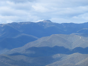
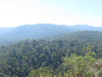
Crosscut Saw, Mt Buggery, Speculation, Koonika, The Razor, The Viking from Mt Howitt WT
It was busy at the Vallejo Gantner hut on a nice afternoon. A few Park staff turned up to do their maintenant work, and it was good to know that the weather conditions would be 'same, same for the next few days..'. A father and son returned from their day hike on the Crosscut Saw. Also several visitors from South Gippsland walked in too.
After lunch I loaded my pack, waved good bye to everyone, walked out, and reunited with my car at the View Point car park on the Mt Howitt Road.
On travelling to Bryce Gorge, I had a quick stop at the Howitt Hut for a photograph.
Howitt Hut with friends of those I met at Vallejo Gantner Hut.
A Qld couple also camped at Bryce Gorge Car Park. BYO water.
Bryce Gorge Waterfalls Loop
I was revisiting this area that I had not been for more than one and a half decades.
What a gorgeous hike! The Bryce Gorge Waterfalls track was well-maintained and well-marked. I enjoyed the views of the open plains, across the gorge, and the waterfalls and in particular, around the Conglomerate Falls. The falls water was so pristine and delicious.
Bryce Gorge plains and Guys Hut
Conglomerate Falls and the stunning views across the gorge
This area warrants another return for an overnighter camp!
Conglomerate falls (L) and Piemans falls (R) from the viewing platforms
Second night at Bryce Gorge campsite. Light rain came and went in the late evenings.
A nearby attraction was the Dimmick Lookout, but the road in was realy rough for the car. There were a few pot holes filled with water and it seemed more suited to a high clearance vehicle.
There were many places I wanted to revisit on the way out, but time and weather did not permit. I missed the campsite at Kelly Hut for the walks to Mt Reynard and Mt Arbuckle near the junction of Howitt Road, Moroka Road and Tamboritha Road. I will definitely come back for these walking tracks later.
Bennison Lookout on Tamboritha Road, after passing B1 Track
Could not stop here for the views on the evening when I was travelling into the area,
so I stopped on the way out.
Wellington River Short Loop
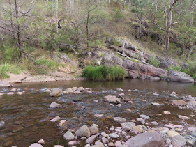
The information sign (L) on the start of the 17-river-crossing hike up the Wellington River to Lake Tali Karng (R) I had a bite to eat at Playtus Campsite on the Tamboritha Road before taking an overnight walk to check out the first few of the river crossings.
The river section at Wellington Bridge
GPS file of the short walk.
Wellington River WT - overnight pack
After checking out a few crossings near the start of the Tali Karng pack-carrying walk, I was so lucky to meet up with a hiker who had just walked out. I did not hesitate to ask about the river crossings and was pleased to hear "Only the third and the fourth crossings were about knee depth and the rest were just paddling." It was a relief and I also thanked him for the time to show me some challenging section on the hiking SV map1:50 000
Revisiting the full track was not in my plan for this adventure, but because it was a long drive to get there and the weather was good and the river crossings were possible, I felt that it was worthwhile to do an overnight walk up the river at my own pace and to pitch my hiking tent by the river. I was glad that I did it. There was a minor issue with setting up the tent because I had not used that tent for quite a while, plus, some early morning showers also delayed the packing for the start of the overnight hike.
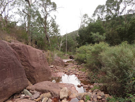
The second and the third crossings.
Lunch spot.
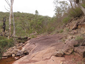
The seventh river crossing (R) with the tent site about 30m away southeast. I forgot to take any photos of my hiking tent setup because it showered in both the late evening and early morning.
GPS file of the Wellington River overnight walk.
Car camping tent at Platypus Camp.
Huggets Campground to Dermodys Picnic Campground trek failed:
The planned walk was a 19.2 km out-and-back trail from Huggets to Dermodys campground. I travelled along Kentucky Road which was fine up to the lookout and then there was a big hump at the start of the very steep descent which looked too severe for the Subaru Outback so I hesitated in taking the risk. It'd be fine for a high clearance vehicle, IMO.
I travelled back out to the main road and headed for Briagolong and then Blue Pool Campground.
Blue Pool Walk-In Campground with loos, water and tables
The short hike loop with the lookout
It was an enjoyable walk and a sunny day. While having lunch I dried both tents. The forecast was fine until the next day. Hence, after checking out maps for the last day, Lawson Falls was chosen as the next walk.
I had a bit of the problems while I was travelling on A1 and M1 (on and off the highway, road work..). I also missed the planned campground on Forest Road due to darkness and so I slept in the car at the falls carpark.
Discovery Walking Track and Lawson Falls loop
GPS file of the Discovery WT and Lawson Falls
Lawson Falls
After leaving the falls carpark and/or picnic area, at 300 m down the track there is a choice of going 1.1 km straight to the falls or doing the 8-km Discovery WT loop which involves a steep 200 m climb and down again. It was a good waterfall with a good flow and well worth the detour.