Showing posts with label river crossing. Show all posts

16 December 2014

Sheoak Creek & Lower Cumberland Circuit

Lorne Waterfalls - Walk Three
Lower and Upper Kalimna Falls, and Cumberland Falls 

Length: 15.4km,  Time: 5hours,  Type: Loop
Max Elevation: 295m,  Grade: Easy – Medium

Start and finish at the Sheoak Picnic Area on the Garvey Track, which is a park management track. Follow the Kalimna Falls sign at the east end of the picnic ground.  The Kalimna Falls track crosses the Garvey Track and then you can follow either of the two tracks along either side of Sheoak Creek to the Lower Kalimna Falls (2.9km) and the Upper Kalimna Falls (4.1km), then back track to a link track, which takes you across Little Sheoak Creek back to the Garvey Track.  Then, walk 1.2km east-north-east along The Garvey Track to the Cumberland River turn off.

The path to the Cumberland River is 1.5km and steep at the river end of the track.  At the river, turn right following the track along the Cumberland River about 400m to the falls.  There is a river crossing before reaching the falls.  Then retrace your steps back to the Garvey Track and continue down the track back to the start.  There is an alternative route back to the picnic area on the Castle Rock access track. 

The start                             Lower Kalimna Falls

Upper Kalimna Falls                                Sheoak Creek

 
Cumberland River Track & Falls
 
GPS route on GE
and
(Lorne Waterfalls - Walk Three)


(Lorne Waterfalls - Walk One)

12 December 2014

Erskine & Cora Lynn Valleys Circuit

Lorne Waterfalls - Walk One
 
Length: 22km
Duration: 6 -7 hours
Grade: Medium
Elevation: 433m
Style: Walking track with many river & creek crossings over stones
Start/Finish: Lorne
Melbourne: 140km
Best time: Late winter & early spring (when the waterfalls flow at their best)

Track & map info: Walks & Waterfalls, Surfcoast Shire.
Topographic map: optional.
Erskine River Track and Cora Lynn Creek Track are well marked.

The walk starts from Kia Ora Caravan Park, which is located opposite to the Lorne Visitor Centre.  The entrance is on Erskine Avenue and there is Parks Victoria signpost showing the 7km length of the Erskine River walking track.

There is no doubt that this track is popular because of the starting point in the Lorne township, the attractive waterfalls and the wild Erskine River and gorge.  The path winds through the Erskine Valley, which is filled with tall trees and ferns.  It follows the river upstream and there are some river crossings.  The track passes The Rapids, Splitter Falls, Straw Falls and finishes at the base of the Erskine Falls, 300m past Straw Falls.  Erskine Falls is one of the highest and most attractive waterfalls in the Otways, Victoria.

After having fun with the camera and a chat with tourists at the Erskine Falls, we had a steep climb up steps, which led to the car park, where there is a signpost to Blanket Leaf Picnic Area.  This is the start of the 3km track, which links the Erskine Valley to the Cora Lynn Valley and saves about 3kms of road walking.  A big thank you.

On reaching the Erskine Falls Rd, cross the road to get to the start of the Cora Lynn Creek Track.  Then, a short gentle descent goes past a hike-in campsite and leads to the Cora Lynn Cascades.  From here, the track goes through a beautiful narrow gorge and the creek that feeds the cascades, is crossed many times before reaching Cora Lynn car park.  After checking out the map from the “Walks & Waterfalls” brochure, we followed the road SSE out to Green Break Tk, turned right and walked down to Allenvale Rd, and then turned left onto Otway St to get back to the start in Lorne.

 Erskine Valley (L)         At the base of Erskine Falls (R)

Cora Lynn Cascades

Erskine & Cora Lynn Valleys Circuit Walk
and
A video YouTube of the waterfalls in the valleys

It was rather a long day to do this two valleys circuit and I would suggest an early start to take it all in especially when days are short.  We ended up having a late dinner at “Chopsticks” restaurant in town.  Wear comfortable walking boots and avoid this walk after heavy rain, when the tracks and rocks become muddy and very slippery.  This walk can be done as an overnight hike using the walk-in campsite, which is located below the Blanket Leaf Picnic Area.  Moreover, with a few hike-in campsites and many other waterfalls walks nearby, it is also possible to have an extended hike of 3 to 4 days in the area.


(Lorne Waterfalls - Walk Three)

01 January 2014

Genoa River Gorge

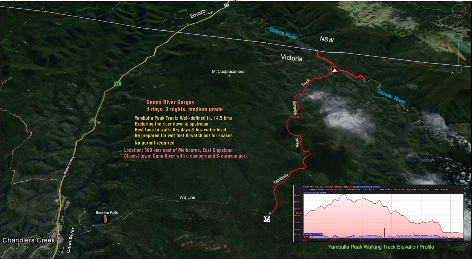
4 days 3 nights, medium grade

Location:  500 kms east of Melbourne, East Gippsland.
Closest town:  Cann River (about 38 kms) with a nice campground & caravan park
Best time to explore:  Dry days and low water level
River Condition:  0.6m as Bureau of Meteorology’s forecast. 
Yambulla Peak Walking Track:  Well-defined track
Walk registration is not applied
Compass:  Not really needed, mainly following the river down & upstream
GPS:  Optional
Maps:  Vicmap and Online Memory-Map Topo
Guidebook:  Take a Walk in Victoria’s National Parks
Parks Victoria Park Notes: www.parkweb.vic.gov.au


Day 1: Yambulla Peak Track to Genoa River, 14.5 kms, 6 to 7 hours

The day started with the packing of food for 3 breakfasts, 3 dinners and 4 lunches.  Careful preparation was needed due to a forecast of showers and rain for the last two days, which would be a day trip to northern gorge and the day of walking out from the river to the starting point.  We had a visit to Beehive Falls on the drive to the start of the walk, which was about 9.5kms away and situated on the “WB Line” road with access to this road from the Monaro Hwy

Beehive Falls


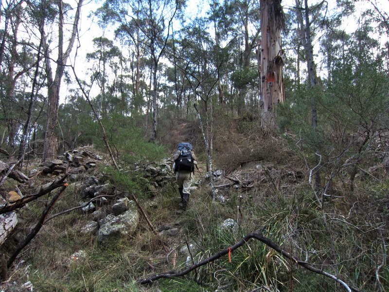
After leaving the carpark, passing a gate (at height of 429m) and the park’s box containing survey forms, the track started to climb.  We went through two hills at 497m & 541m height, then dropped down to a forested gully.  A steep climb up took us near the highest point (683m) on the track, where we stopped for lunch with good views of the range on the left.

Yambulla Peak Track

From here, the track was mostly down with a few ups.  After lunch, we met 2 DSE staff, who were in an all-terrain vehicle and on their way back after a check on the track and the Genoa River conditions.  We were relieved to hear that the water level was low enough for crossing and exploring the banks of the river.  After driving off, they had fun tackling the steep slope we had just come down.  We continued over ups and downs, past some granite boulders and had a clear view of Mt Coopracambra and the range through the trees on the left.  

Photo stop

The last section of the Yambulla Peak Track was a steep downhill to a small creek.  We crossed the creek then followed an over-grown pad to reach the banks of the Genoa River.  It was about 6.30pm, when we arrived at the junction and found that the water was a bit high and so decided to search for a small piece of lawn to pitch up tent on this side.  It took us about 6 hours plus stops to get here, not the 5 hours mentioned in the guidebook.  At this stage, we were unsure whether to move camp the next day.  We had couscous and salmon for tea.  Custard and dried fruit was the desert for my companion, while I had cappuccino.  It got dark about 8.40pm.

 A little "garden" found near the junction of YPT & Genoa River 

Day 2:  Exploring part of Southern Gorge with a day pack

It was a sunny morning and at the crossing spot, the river bottom could be seen.  As forecast by BOM, the level of water was 0.6m; about knee-high.  With our Crocs, we crossed the river without difficulty and our boots were hung in front of us.  After crossing to the opposite bank, we put on our boots and built a small rock cairn to mark the position of the Crocs for the return.  A GPS waypoint of this location was also recorded.  We then scouted for a possible campsite and quickly identified one on the sandy bank.  My companion was not keen on camping on sand; therefore, the thought of moving was abandoned.

 
 The crossing, where the YPT meets the Genoa River

The walk mainly followed the river down stream involving rock hopping and rock scrambling.  If the river bank was too scrubby to bash through and the water level was not high, an easy way to make progress was to wade.  I enjoy wading.

Exploring down stream

 If low water level, go for it!

Waterfalls

The going was slow.  It took us 1 hour to complete 1km.  About 1.4 km from the crossing, we spotted an overhanging cave on the opposite bank; so we stopped for a photo.  At this point, the water was high and the scrub was thick and so we had a bit of hard time to get through the scrub. Then, around the bend, we waded on a sandy river bed with knee-high water to go across and walked on a large sandbank to reach the southern gorge.  From here, we bush bashed a bit then went across a small cascade to reach the other bank, where we looked for a sheltered spot on a big flat boulder for lunch.  We got out the billy to boil water for soup.

An overhanging cave on the opposite bank
Approaching Genoa Southern Gorge
 
Lunch with gorge view

After lunch, we continued on the right bank, which involved some rock hopping for about 100m until we reached the mouth of the Yambulla Creek.  Then, a little later we approached the end of the first section of the Southern Gorge.  At this point, we decided to turn around and retraced our steps back to the cairn.  Collecting the crocks, we crossed the river and headed back up to the campsite.  There was a pretty sunset over Southern Genoa River that evening.

The mouth of Yambulla Creek
Turnback point
A section of the river filled with boulders

We were hold up by this guy near the mouth of Yambulla Creek

then, it freezed and/or posed.

Rock-hopping & scrub-bashing on the way back

Not far now, so it was time for a rest.  These gaiters, a New Year gift to me.

Sunset on the Southern Genoa River Gorge.

Day 3:  Exploring Northern Gorge 

We were rather confident with the river crossing today after the two river crossings and lots of wading yesterday.  Unlike yesterday’s downstream walk, today we followed the river upstream.  It was a bit cloudy and it seemed that the river level was lower and so the going was less demanding.  We did more wading along the edge of the river to avoid scrub bashing

Heading upstream from the track & river crossing point

 Low water noticed on a boulder-filled section of the river

Crossing from side to side 

At a large bend, on the bank of the river, my presence woke up a black snake and while trying to move away from it, I lost balance and had a fall onto slippery rocks.  As a result, I had bruising and swelling of my hand and fingers.  Not far from that, on a dry overflow, I spotted another creature (it was likely another snake) fleeing quickly, when it heard us coming

Cherry tree? in scrub near the river bank

We had lunch on a large rocky slab.  While the stove was turned on, I had a quick dip in the river to fresh up before continuing the exploration.  Based on the GPS UTM grid reference and the rock band of a few huge boulders across the river, I was pretty sure that we were at the state border.  And also, based on the walk guide book, there should be a cairn located somewhere on the west bank

View back to the lunch spot

The Victoria and NSW border

After lunch, it started to shower lightly.  We continued on about 100 m until we reached a few pools and decided to turn around.  On the way back, we caught sight of a possible cairn on the other side of the river.  When close to the lunch spot, we noticed 2 snakes coiling up about 1m away from each other near the river bank.  Back at the lunch spot, I crossed the river with the hope that what I had recently seen was what we had been searching for.  Finally, we found a pile of rocks, that were likely to be the cairn!  From here on, we had to wear light rain gear until reaching the campsite, where my tarp was put into good use for dinner preparation.  After meal, we called it the day.

 We turned back at this point in light rain jackets

 Snake territory near the border

The two snakes spotted near the boulder in the middle of this photo

 "The border cairn"

"Our cairn"

Wild flowers

A boulder-filled section of the Genoa River on the way back

There was a small gap between the tent and the tarp.  
Wonder if any lite & reasonably-priced tarp, fitted to the Moondance 2 tent.

Day 4:  Back to the start, 14.5 kms, 6 to 7 hours.

We started an hour earlier than the day we walked in.  Having walked the well-defined Yambulla Peak Track, I did not bother to put on the gaiters.  The day was a bit warm, coupled with the length and the many uphills and downhills of the track, it was a rather tiring day for us.  Hence, we felt great relief when the survey box near the gate was in sight.  It took almost the same time as the walk-in.

Genoa River Gorge Walk view with GE

I then had a quick dip in the Genoa River East Branch near the Highway before continuing the drive to Cann River in order to catch up with cold beer, pub meal and a campsite.  Luckily, the campground, which used to be a caravan park, was not very crowded and the booking could be arranged through the pub.  The fee for two people was very reasonable and I would recommend it to those, who want to camp with basic facilities.

 The drive out via the WB Line

En route back from the Genoa Gorges Walk, POIs, we had a short visit to, will be here soon.

04 May 2013

Adventure into the least visited sections of the Lerderderg Gorge

Ah Kow Tk – Lerderderg River – Bears Head Range Tk – Blackwood Ranges Tk

Update to the existing 3 to 4 day Lerderderg Gorge walk undertaken two years ago (Watties Creek (Clearwater Crk) and The Old River Circuit Walk)

The difference between the two were:
Walked in and went down to the Lerderderg River via the Ah Kow Track, unlike the previous walk, where I walked up the steep ascent from the river, and then walked out.

The reason for the return was to identify how I had missed out the Ah Kow Track on the ascent, and to find the start of the route which led down to “a waterfall” located south of The Old River.

I suggest:

  • For a short overnight walk, leave early morning.  If you want an early start, camp can be set up at the start of Bears Head Range Track.  If a late start, the night can be spent at Ah Kow camping area located just on the opposite bank of the Lerderderg River.
  • Take your time on the steep descent down to the Lerderderg River.  A trekking pole can be very helpful.  The track is so steep that I had to slide down on my backside.
  • The river was not flowing when we were there.  Only one or two decent pools of drinkable water along the dry river bed.  There may be a need to treat water.

     
    Ah Kow Tk – Lerderderg River – Bears Head Range Tk – Blackwood Ranges Tk 

    The walk started and ended at 65 Lohs Lane, which was about 600m south of Mt Black Wood.  There was a signpost at the gate.  Went through the gate, passed some worn red rail carriages, and continued on until reaching a signpost at the end of Lohs Lane, which showed Blackwood Ranges Track (about 250m from the starting point).  Turned right here and headed 130m southeast which saw us at an entry gate into the park.  Then, another 107m took us to the junction of Ah Kow and Blackwood Ranges Tracks, where route finding skills were required to find the start of Ah Kow Tk, which used to be an old vehicle track.  

     The start of Ah Kow Track

    The track now turned northeast and after a pleasant walk along for 1.06 km, we arrived at a memorial of a Melton bushwalker, which was located on a knoll at 559m.  From here, the track became narrow and the closer we got to the gorge, the steeper the track was.  Care should be taken on a 140m steep descent to an emergency marker LER 513 on the bank of the Lerderderg River.

    Emergency marker LER 513 on the river bank

    Ah Kow Track Information 

    As suggested, the Ah Kow mine site and/or camping area was just on the opposite bank of the river, where a group of Chinese had lived and grown vegetable for food in the late 1870s.  Keep an eye out for a plastic orange triangle on a big tree and an emergency marker, LER 514 could be seen up there too.  

     
    A plastic orange triangle on a big tree

    Ah Kow camping area

    Ah Kow Ruin / Lerderderg River Track Info

    The section from Ah Kow Tk to Bears Head Range Tk was dry.  The walk mainly followed the dry rocky riverbed downstream for about 2.3 km until the Old River on the left was reached.   

     Lerderderg River 

    Walked a further 100m to reach the Bears Head Range campsite, which is located on a small grassy flat above the right hand bank of the river, which is also the start of the Bears Head Range Track.   

    However, there were sufficient pools of water available in the river bed to provide water for cooking and the climb out.  So if you're heading into this section of the river, bring something to treat your water

     One of few pools of water in the river bed

    Reaching the Bears Head Range campsite

    Allan doing the packing

    The climb up the Bear Head Range track was extremely steep (the grade is 1 in 6 average) and required careful choice of route to avoid pack hauling narrow crevices..  There are lots of good views of the river on the way up and it is rather well marked with white triangles on the trees. 

     The start of Bears Head Range Track


    Lerderderg Gorge

    Me on Bears Head Range Tk with Blackwood Ranges in the background


    After 1.5 km the slope eases to 1 in 10 and the whole climb took about 2 hours. 

    Once the Blackwood Range track was reached, the walker can either take the left turn to go around the Ah Kow Reference Area or the right turn to take the walker’s track around the locked vehicle gate to follow a short four wheel drive track to the junction of the Foxy Range Track, where a right turn takes the walker back to the Ah Kow Track junction, and then allows the walker to retrace steps back to Lohs Lane carpark.  

    Junction with Blackwood Ranges Track

     Blackwood Ranges Track / Bears Head Track Info

    The walking track around the locked vehicle gate

    A challenging daywalk, or a comfortable overnight walk.  See the elevation profile of the route taken until reaching the Blackwood Ranges Track.