Showing posts with label Montane WT. Show all posts

25 May 2025

Montane Walking Track, Precipice Plain Lookout, and Carmichael Falls


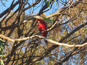
Breakie time for me and my juvenile Crimson Rosella. A big thank you for your pose.


Montane Walking Track (Section 1 - 3.3 km, Section 2 - 3.2 km) - Precipice Plain Lookout - Montane WT (Section 3 - 2.6 km) - Carmichael Falls Walk (2 km return).
 
The Montane Walking Track officially starts at the Forest Walks trailhead, on Great Alpine Road (B500). It is about 200 m north of the Visitor Info Centre. You pass Crisps Hut then cross the road.


There is also the option for an easy 1 km Montane Loop. The tracks junction is signposted and Montane WT takes the right turn here onto a foot pad and heads east. From here the track runs parallel to the Great Alpine Rd for about 3 km then turn south to meet the track on the other side of the road at Slippery Pinch where there is a gate. 

Grey Gum bark and tussock grass meadow.
 
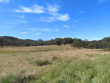
The start of Section 2 of the Montane WT is on a tussock grass pad. It was very different from walking on the Razorback ridge the other day and it is recommended you keep to the pad because it is not easy to get back onto the pad when you are off it or lose it.
 
There are some orange triangular markers on the track. This is where I met a couple while I was having lunch. We had a quick chat and talked about other walks in the Dinner Plain area. The track then turns west. 
 
The last part of Section 2 is a very pleasant walk through the snowgum forest to meet up with the  Precipice Plain Walk. Going through the gate at the end of the walking track, turn left and follow the vehicle track south for about 1 km to reach a lovely natural lookout at the end of the road.
 
Precipice Plain Lookout and Mt Tabletop (Square Mountain)
 
The 1 km road walk back to the junction where Montane WT meets Precipice Plain Walk was a bit boring. Near where the walking track joins the road, I went through the gate to see if there was an alternative walking track to the road. It was worth the check. Montane WT, Section 3 seemed to be continued on a fainted foot pad inside the gate, running along the old fence line.
 
I used a compass and a handheld gps (with a preloaded route) a couple of times to stay on the pad for about 2 km and guide me back to the road (Dinner Plain Track) near the Carmichael Falls Walk turn off, which is about 1 km south of the Visitor Info Centre. I took this turn off to the falls.

The path to Carmichael Falls (Second Tier)

After the falls visit, walk 1 km back up to Dinner Plain 4WD Track. Turn left and follow the road to Dinner Plain Village. It was rather a long day, but worth the effort.

Dinner Plain Track with a seasonal gate
 

Dinner Plain

Dinner Plain is a nice little snow village that also offers a great location for outdoor adventurers in Summer. The alpine village of Dinner Plain is located 13 km southeast of Hotham Village, just about 20 minutes for a slow driver like mine.


There was a huge construction project outside the Visitor Info Centre and I had a quick stop to pick up an official walk guide for the Dinner Plain area. I arrived at the planned destination and it was lucky to find a suitable spot for my little car camping tent, a previous light weight hiking tent that is easy and fast to pitch.
 

 Day shelter Carpark
 
 
 My neighbour's 4WD with a rooftop, a perfect arrangement for two.
 
It was early enough for a walking tour around the ski resort.


Mt Tabletop WT (Square Mount)

Distance: 10 km return. Grade: medium
Track: marked by orange triangular markers
Map: See the Dinner Plain Tracks & Trails map in the Montane WT, Precipice Plain Lookout, and Carmichael Falls Walk blog. 
 
Start / End: JB Plain Hut / Walk-In Campground about 100 m off Great Alpine Road (B500) and
about 1.5 km west of Dinner Plain Village. 
 
Access to a drop loo. BYO water. 
 
 
 JB Plain Hut with campground.
 
Path across the plains for 0.5 km.
 
Crossing the snowgum woodland. 
 
 Mt Tabletop from the track 


The plateau. Watch out for snakes on a sunny day.
Return by the same route. 
 
I returned early enough to take a short walk up to Dead Timber Hill Lookout (about 30 minutes return with a break or two and photos). The start is on the other side of the road and opposite to the car park. The track is signposted.

Mt Feathertop from Dead Timber Hill Lookout.

 Well worth a climb

What a view!
I returned by the same route.

But, you could continue on this track, Dead Timber Hill WT and walk east for about 1.5 km which will take you to the start of Room with a View Walking Track (easy, 3 km return).
 
Room with a View WT taking you through the snowgum forest to an open plain.
 
 
Views of Mt Hotham, Mt Feathertop, Bogong High Plains, and the Cobungra River are from the lookout at Room With A View